


queen's cain ireland

bena42
User
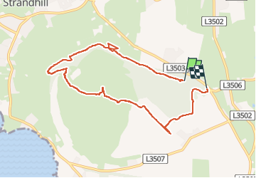

Length
7.4 km

Max alt
319 m

Uphill gradient
325 m
Km-Effort
11.8 km

Min alt
80 m

Downhill gradient
346 m
Boucle
No
Creation date :
2023-02-09 16:21:34.064
Updated on :
2023-02-09 18:16:41.404
1h54
Difficulty : Very difficult

FREE GPS app for hiking
 SityTrail
IGN / Geographical institutes
SityTrail World
The world is yours!
About
Trail Walking of 7.4 km to be discovered at Unknown, County Sligo, Sligo Municipal Borough District. This trail is proposed by bena42.
Positioning
Country:
Ireland
Region :
Unknown
Department/Province :
County Sligo
Municipality :
Sligo Municipal Borough District
Location:
Knockaree ED
Start:(Dec)
Start:(UTM)
528993 ; 6012623 (29U) N.
Comments
Trails nearby